Boston to Orlando – April 2006
12 States in 12 Days
This is something I had wanted to do for years, drive down the east coast of the United States from the cold and damp of Massachusetts to the warm sunshine of Florida. The big deterrent was the high charge for renting a car in one place and dropping it off in another, more than 1000 miles away. There are ways round it, but none of them suitable for the way I wanted to travel, and in the end I decided to swallow it on the basis that it was to be a one-time experience.
The flight was booked from Gatwick to Boston via Philadelphia with US Airways, but in the event I was transferred to a flight via Charlotte, North Carolina, which seemed rather silly, because Charlotte is more than half way from Boston to Orlando, but that is how things sometimes work out.
Massachusetts
At Boston Airport I collected the car from Alamo. It was a choice between a Chevrolet Cavalier and a Saturn Ion, so I chose the Saturn because it was unknown in England, and I would be able to tell everyone that it was a much bigger and better car than it actually was.
After spending the night in a motel in Malden I started the journey proper. A few years earlier I had had a couple of days in Boston, and it was not my intention to spend any time in the city on this trip, but there was just one place I wanted to visit, namely the Larz Anderson Museum. Now, don't stop reading, it was the only car museum on the trip, and a rather special one. At the beginning of the 20th century Mr.Anderson, a pioneer motorist, owned a large estate in Brookline, which was then on the outskirts of Boston. Every few years he bought an expensive new car, and put the old one in his motor house. Eventually he built up a collection of cars, and had a new motor house built in the style of a French chateau, and that is where the cars are today, in the condition that they were when he last used them.
Finding the museum proved to be difficult, and the two Hispanic girls in a fast food place had no idea, although one of them said I had nice eyes. In the search I came across The Country Club, a golf and sports club, and when I went through the door it was like walking straight from Massachusetts into Surrey, a little bit of Olde England in the middle of New England. At least the ladies in the oak-panelled office knew where the museum was.
From Boston the route ran roughly south east past Worcester and entered Connecticut on the Interstate freeway I-84.
Connecticut
The drive through Connecticut was pleasant but generally unexciting, via Hartford and Danbury, into southern New York State near Brewster.
New York State
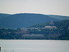
After the Fishkill Mountains, which are mountains in name only, I turned south on to a scenic minor road that ran along the eastern side of the Hudson river, from which there was an astonishing view of the West Point Military Academy on the other bank. I had imagined West Point to be a large Victorian-style building in the middle of parkland, but in fact for all practical purposes it is a fair-sized town.
Things went a bit wrong after crossing the Hudson at Camp Smith, and I got lost in Harriman State Park, which is a forest, and eventually picked up Interstates 87 and 287 to New Jersey.
New Jersey
I-287 led straight to my night stop, the Howard Johnson motel in a dormitory town called Parsippany, about 35 miles west of New York City. I had discovered Parsippany on a previous trip after giving up trying to drive into Manhattan or find accommodation close to New York. It is a boring town, but has cheap motels and a dedicated fast bus service into the capital, taking about 45 minutes. Tickets cannot be bought on the bus, but are obtainable in various shops in the town, and I got one after getting sorted in the evening.
The next morning, a Saturday, the temperature was about 45ºF and raining, just how I had imagined the start of my trip would be. The motel receptionist said the bus stop was in front of the Holiday Inn, next door. The 4 people standing on the grass verge in front of the Holiday Inn said they thought it was the bus stop, and when the bus arrived after about 15 minutes we were all pretty well soaked.
There can be few places on earth more depressing than New York Port Authority Bus Terminal on a wet and windy Saturday morning and the street outside was no better. It was almost deserted apart from hooded figures standing in every doorway gazing into space, which did nothing to enhance the walk through to the theatre district. However, after reaching a more civilised area and having a good breakfast in a proper New York deli I felt considerably cheered.
On my previous visit to New York, for one day, I explored the area south from the bus terminal, including the Empire State Building, Greenwich Village, The World Trade Center, Wall Street, Brooklyn Bridge, City Hall etc. This time I went north and east through the rain and wind, taking in Times Square, Grand Central Station, the Chrysler Building, United Nations, and a quick look at Central Park, which was deserted and uninviting, despite the blossom on the trees.
Grand Central Station, with its fabulous architecture, marble and chandeliers, was quite stunning, the extreme opposite to the concrete jungle bus terminal. In the basement was a huge food market, and the whole place far exceeded expectation. As I was walking through Times Square two fire engines appeared, sirens blaring and full-sized American flags streaming out behind them. All the people around moved to the edge of the pavement and clapped as the machines went past, showing that New Yorkers had not forgotten the heroic actions of their fire fighters five years earlier. This could only be America.
By the time the bus got back to Parsippany it was dark, and somehow I missed the bus stop opposite to the Holiday Inn, which was not surprising really, because there wasn't one. As a result I finished up ¾ mile farther along the road, by chance in front of a large restaurant. During the meal the rain got worse, and eventually I had to fight my way back to the Howard Johnson in the dark over an assault course of banks, ditches, areas of rubble and other obstacles along the side of the main road. American urban highways are not designed for pedestrians, and it was a rather ignominious end to a good day.
The next morning I managed an early start and set off for Washington DC through the ongoing rain. The route down to Trenton was part freeway, part state road, and after Trenton, in worsening weather, I took the freeway again east of the Delaware River to avoid Philadelphia. At Deepwater I crossed the river to Wilmington in Delaware.
Delaware
This was the state in which I did the least driving, a total of about 12 miles, but the weather improved at last as I went through into Maryland.
Maryland
From Wilmington I took I-95 right through to Washington DC, and I cannot say that it was a particularly memorable journey.
Washington DC
Now, I know that I am cheating here by counting the District of Columbia as a state, because it is not one, but on the other hand it is not in any other state either. The founding fathers of the United States decreed that it should be neutral territory as far as states are concerned, and if I don't count it there will be hole in the middle of my journey on the map.
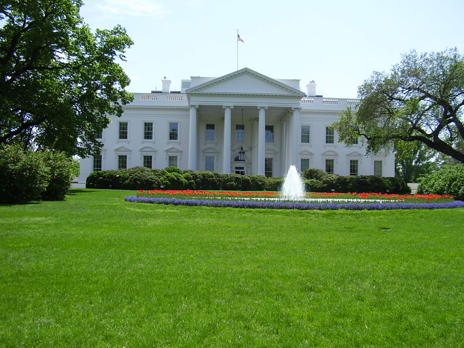
 It was Sunday and I drove straight to the middle of Washington, arriving about midday, by which time the weather had turned really warm and sunny. It was easy to park, and after a snack I walked through to the White House. The most surprising thing was how close it was possible to get on foot to the front of the building, with the iconic view across the lawn. From there I walked most of the length of Constitution Avenue towards the Capitol, with the Lincoln Memorial and Washington Monument on the right hand side, and imposing neo-classical government buildings lining much of the road. It was all very impressive, and it was easy to imagine that the British government of the period must have realised that the game was up as far as world domination was concerned when they saw the capital of the United States taking shape.
In Constitution Avenue about 20 people went past me on a Segway tour, something I would like to have done had I had the time. For  those who have never seen one, the Segway is a high tech personal transportation device consisting of a platform on which the rider stands between two wheels at the sides, with a vertical tube with handlebars in front. Balance is maintained by some gyroscopic means controlled by a computer. They are battery-powered and almost silent.
From Washington I had no definite route planned, but was thinking of going south west into Virginia. The centre of Washington might be very smart, but that cannot be said of some of the suburbs, and due to a misleading direction sign on the way out of the city I finished up in one of those areas where it is best not to stop. Once I managed to escape without being dragged from the car and mugged I realised that I was on the eastern side of the city, and stuck in a dreadful traffic jam, which according to the radio was seven miles long. In view of this I decided to go back into Maryland and down to Virginia on the eastern side of the Potomac River.
The road I took is known as Indian Head Highway, and is not a freeway, but is like one, which is rather strange because Indian Head and neighbouring places are actually quite small. The high standard of the road is probably due to the presence of a small military base at Indian Head, but the amount of traffic going there on the Sunday evening was astonishing. In typical American fashion there were two lanes of traffic moving side by side at 60mph, and I can only assume that everyone from the area must have been to Washington for the day. The orderly proceedings were disrupted momentarily (a word which has a different meaning in the USA) when a motorcycle came up from behind travelling, in my estimation, at over 150mph. It went straight between the two lines of cars, and everything else appeared to be standing still. A few miles down the road we came to some traffic lights, and the rider was standing there with his helmet off, waiting for his mates, who were travelling at the speed of the rest of the traffic.
Shortly before Indian Head I turned eastwards to a small town called La Plata, and after finding a motel for the night I decided on a plan for the rest of the journey to Orlando. As I was already quite close to the coast it seemed that the most interesting route would be to drive to Norfolk, Virginia, and then through the string of islands off North Carolina known as The Outer Banks. This would take me through Kitty Hawk, the site of the Wright Brothers first powered flight.
The next morning a few miles south of La Plata, in heavy mist, I crossed the Potomac bridge into Virginia. This was to be the first of many bridges, tunnels and ferries in the next few days.
Virginia
 After stopping briefly for the beautiful views across the river at Potomac Beach and Colonial Beach I drove down to Norfolk via Farnham, Lancaster and Gloucester, passing also through Warsaw, which did seem a bit out of place. The bridge over the Rappahannock River was about 2 miles long, and I lost count of how many others there were.
The next stop was Virginia Beach, reached by a minor coastal road (more bridges) after the tunnel between Hampton and Chesapeake, and here I spent a couple of hours, mostly walking on the beach, as I needed some exercise after all the driving. As I was not fishing I was too mean to pay the $7 to go on the fishing pier, and when I got back to the car, too mean to pay the toll on the Norfolk - Virginia Beach Expressway. Instead I found a way round using minor roads.
North Carolina
A few miles down highway 168 was the border into North Carolina and after a couple more bridges I reached Kitty Hawk, which was to be my night stop. The first thing that struck me about Kitty Hawk was the extraordinary lack of development, considering that it is such a famous place. Most of the buildings were wooden houses in the traditional local style and at first there seemed to be no motels, but then I found a recently-opened Days Inn in Kill Devil Hills, just down the road. There were a few restaurants and a K-mart, but the whole place had an air of being very low key.
Before doing anything else the next morning I phoned through to the Okracoke - Cedar Island ferry to reserve a place on the 6pm crossing. I had found out about this from a guide book, and if you don't book in advance you can drive right down through the Outer Banks and be unable to get a ferry across to the mainland at the end. After breakfast I went for a walk on the beach and then drove to the Wright Brothers Memorial.
 Now, from my experience the Americans do this sort of thing either very well or very badly, and the Wright Brothers Memorial is outstandingly good. By some miracle the site of their pioneer flight has remained intact, and is now a National Park. It consists of a large flat field with a 90ft high sand dune towards one end, which is the actual Kill Devil Hill from which the first flight took place. On the hill is a 60ft grey granite monument commemorating the event and a wonderful full-size bronze sculpture of the aircraft and the people who took part in the launch, including, of course, the two brothers. This was put in place in 2003 to celebrate the centenary of the flight. In the Visitor Centre towards the other end of the field is a replica of the aircraft and a vast amount of other information about the early days of powered flight.
It was then a fast drive south through Bodie Island and Hatteras Island to the Hatteras-Okracoke ferry. On the way I passed through a number of places consisting mainly of wooden houses, often on stilts and almost all with a tower, usually on one corner, to provide a view over the sea wall or other properties. From a distance these settlements looked like fantasy towns, and there were also a couple of lighthouses, painted up with stripes in the style that Americans are very fond of.
 Eventually I came to the Hatteras-Ocracoke ferry, which is free, taking about 40 minutes and holds 30 cars parked along both sides of a high superstructure in the middle. Throughout the entire journey the funnel belched out thick black smoke which went all over the cars on the side where I was parked. More about that later. Apart from the smoke, it was too foggy to see much during the crossing anyway.
There was nothing much to see on Ocracoke Island excepting Ockracoke itself, and as I arrived at 3 o'clock for the 6pm ferry I had plenty of time to look around after getting something to eat. It was actually a very attractive marine village, with a wooden post office and lots of shops. There is also a small British cemetery containing the graves of a number of British seamen who were killed in the second World War defending shipping off the coast of Carolina.
 The Ocracoke-Cedar Island ferry is the same general style as the Hatteras one used earlier but is considerably larger and has a much longer crossing, at about 20 miles. The journey takes about 2¼ hours and at the time of my trip cost $10 for a car and passengers. After about an hour we were out of sight of land from the car deck, which I found somewhat surprising, considering that the vessel was like a large flat-bottomed punt, hardly the sort of thing for putting out to sea. However, when I looked at the map I realised that we were actually in the Pamlico Sound, which is entirely sheltered from the Atlantic by the Outer Banks and explained why the crossing was extremely smooth. The islands continue for a long way south west from Ocracoke, although it is not possible to drive through them.
When we reached Cedar Island it was pitch dark, and as I left the ferry terminal I discovered that there was a problem with the car. Viewed through the windows any bright lights, particularly headlights, were surrounded by haloes in all colours of the rainbow, making it very difficult to see anything. There was obviously a film of oil on the windows, which must have come from the smoke on the Hatteras ferry. I tried to remove it from the windscreen, with little success, and by the time I finished messing about everybody else had gone. Why they were not so affected I do not know, but perhaps most of them had only been to Ocracoke.
I had no accommodation arranged, and it was unlikely that I would find any on Cedar Island in the dark. The most likely places for motels were Beaufort and Morehead City, and it was a very unpleasant 40-mile drive, although fortunately there was little traffic coming the other way, because Cedar Island is thinly populated and the ferry had stopped running. The first motel I came to was the appropriately named Buccaneer in Morehead City, by which time it was 10pm, and I had no choice but to pay the inflated price demanded. The next morning the first thing I did was to go down the road and get some paper towel and surface cleaner from Kmart to deal with the car windows.
Continuing along the coast through Jacksonville (not the big one in Florida) and Wilmington I entered South Carolina.
South Carolina
For about the next 50 miles the coast road passed through a number of seaside resorts, the largest of which was Myrtle Beach. Many stretches of American coastline are relatively undeveloped, or have small settlements with just a wooden fishing pier, but that cannot be said of the area around Myrtle Beach. It is very highly developed indeed and has attracted a large retirement population. There was a gale-force wind blowing, but it was not cold, and after having a snack I went for a long walk on the beach.
Some distance on from Myrtle Beach the built-up area finished, and the road eventually ran through the edge of the Awendaw National Forest for a long way, with the Intracoastal Waterway on the left hand side. This continued right down to Charleston, where I planned to stay the night. The room in the very basic Motel 6 was better than that in the Buccaneer and less than half the price, although there were some noisy people next door.
Most people probably think of Charleston and Savannah as being similar, as they date from the same period, but actually they are quite different from one another. This was my first visit to Charleston, but I had been to Savannah a few years earlier. The historic area of Savannah covers about a square mile alongside the Savannah River, and contains a fair number of modern buildings intermingled with the old ones that have been preserved.
The historic area of Charleston is on a point of land between the Ashley and Cooper Rivers, effectively set back in a harbour with an open aspect to the Atlantic, and it seemed to me that it was less spoilt by recent development than Savannah. There is also a main street very similar to the ones found in old towns in Europe.
After spending the morning in Charleston I moved on in a general south westerly direction to Hilton Head Island. The whole stretch of coast between the two old towns is broken up by creeks and rivers, rather like parts of Essex, and Hilton Head Island is a genuine island, joined to the mainland by a bridge. There are opportunities for all sorts of sporting and leisure activities, but the thing it is most famous for is golf, as it is the venue for some championship events, with courses all over the island.
On my previous trip to the area I had stayed for a couple of days at Hilton Head, so I booked into the same motel this time and then went down to the beach. It was warm and sunny, and I realised that I had reached the South at last, so by way of celebration I had a meal in a Chinese buffet. When I got back to the motel I heard something going on not far away, and discovered an area called Harbourside with folk singers and street performers entertaining a fair-sized crowd in the dusk alongside a waterway.
") The next morning I went down to the beach and rented a bicycle, as I had done previously. The bicycles were wonderful American cruisers, with wide handlebars and no front brake. The only brake was operated by backpedalling, which takes some getting used to, especially if there is no other way of stopping. They are fine for use on the beach, which is where I started off, but after some distance I came through to the road, and that is when it got quite exciting. A lot of the time there are cycle paths, but when you come to a junction or have to cross a road it is difficult to remember the braking procedure, and on several occasions I finished up with my hands grasping for the non-existent brake levers while my feet slid along the ground.
The next morning I went down to the beach and rented a bicycle, as I had done previously. The bicycles were wonderful American cruisers, with wide handlebars and no front brake. The only brake was operated by backpedalling, which takes some getting used to, especially if there is no other way of stopping. They are fine for use on the beach, which is where I started off, but after some distance I came through to the road, and that is when it got quite exciting. A lot of the time there are cycle paths, but when you come to a junction or have to cross a road it is difficult to remember the braking procedure, and on several occasions I finished up with my hands grasping for the non-existent brake levers while my feet slid along the ground.
Later in the day I resumed my journey, passing through Savannah and into Georgia, to join the I-95 freeway southwards in the direction of Florida.
Georgia
The freeway ran parallel to the coast, which was still fragmented into islands, creeks and rivers. Shortly before Brunswick the freeway passed close to Fort King George, a memorable historic site that I visited on a previous trip. As the name suggests it was British army encampment from 1721 to 1727, to protect Colonial interests from attack by the Spanish, French and Native Americans. It has been very effectively reconstructed in a way that shows the appalling conditions in which the soldiers lived, and was particularly memorable to me for the vast number of insects lying in wait to pounce upon anyone who dared to enter the site, which is on the edge of a marshy creek. On the counter in the ticket office was a spray can of insect repellent which I was invited to apply liberally to any exposed body parts, and all visitors were advised to wear a rather ridiculous hat with netting attached that came down to the waist. When you went into the encampment the need for this became apparent, and how the soldiers survived is hard to imagine. In fact, a large proportion of them didn't, which is why the camp lasted for such a short time.
Near Brunswick I found a motel and went into the Old Brunswick for a meal and look round. It is a very pleasant town on a promontory almost surrounded by water, but protected from the Atlantic by yet more islands.
On the freeway the next morning, about 40 miles south of Brunswick, I came to the Florida Welcome Center.
Florida
Shortly after the state border I turned off the freeway to Amelia Island, which is well known to classic car enthusiasts as the venue for one of the world's best concours events, in which cars worth millions of dollars are displayed and sometimes sold at auction. This was my first visit, and there were no classic cars, but I discovered Fernandina Beach, which I have referred to in another story.
 The main street of Fernandina Beach has a genteel air, and is lined largely with shops purveying antiques and goods of an artistic nature. The traffic travels very slowly and quietly, and if you look as much as if you might be thinking of crossing the
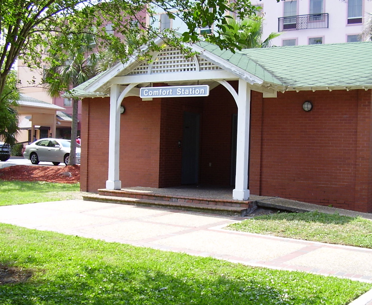
  road the cars will stop. The public lavatories are called Comfort Stations, and I decided to bestow upon Fernandina Beach the title of World Centre of Niceness, which had previously been held by Carmel in California.
Running south from Amelia Island is a long string of narrow islands joined by bridges, carrying the relatively minor highway called A1A, which continues, with a few gaps, all the way down to Miami. The road can be used to by-pass Jacksonville, but this entails using a short ferry to cross the mouth of the St.John's River, which I decided to take. There was a half-hour wait, but the ferry provided a good view of the Mayport Naval Base on the opposite bank of the river.
From here A1A runs through a number of number of beach resorts, and I stopped for some time at Neptune Beach for a walk, and then drove on past largely undeveloped stretches of beach down to St.Augustine.
St.Augustine is the oldest continuously occupied European-founded city in the USA, and dates from 1565, when it was established by a Spanish explorer with a long unpronounceable name. It has a very chequered history, having been fought over for centuries by the Spanish, French and British, getting almost completely destroyed a couple of times in the process. It has a historic area with old buildings, some of which are reproductions, and a wide river with an attractive bridge called The Bridge of Lions. The town has a similar atmosphere to Stratford-upon-Avon, and to my mind it is actually a nicer place, although I am sure I shall get shot for saying that.
There is one problem with St.Augustine, namely difficulty in finding accommodation, especially at weekends. It was late Saturday afternoon when I arrived, and the people in the Visitor Center said I would not find any rooms under $100 and probably none at all. They were right. This whole stretch of coast, for 40 miles down to Daytona is very popular, and at weekends it can be difficult to get in anywhere in Daytona itself, despite the huge number of motels and hotels there.
Eventually I managed to find a room in a really dreadful motel, even by my standards, in Holly Hill near Daytona, and went into the city for a meal. A thing I found rather amusing was that there were ghost tours of Daytona on offer, presumably inspired by the ghost tours of St. Augustine. With its long and violent history St.Augustine might well have ghosts, but Daytona? It would be like offering ghost tours of Stevenage or Basildon.
Daytona is one of my favourite places in the USA, but it has lost much of its character in recent years. With its long tradition of motor racing and driving on the beach it had a unique atmosphere that attracted students from all over the States for the Spring Break and bikers likewise for Bike Week. The tattoo studios, bars, gaming parlours and cheap motels gave the place a slightly hard edge, but some years ago the authorities decided to try to go upmarket and make it into a family resort. Driving on the beach has been greatly reduced and the old motels are gradually being replaced with tower block hotels, so that Daytona is becoming like any other large resort. On one visit I made my views known to the ladies in the Visitor Center, and they said many other people felt the same way, but there was nothing they could do about it.
After checking out of the terrible motel the next morning I had breakfast at Dennys and went on to the Flea and Farmers' Market, where you can find the latest crackpot American novelties, some of which make good presents because they will not have reached Britain yet. Next stop was the International Speedway racing circuit, where testing was in progress, and it was possible to get right up to within a few feet of the cars as they hurtled past just below the safety wall. Free of charge, as well. Then to Daytona Beach, where I managed to find a room in a decent motel and spent the rest of the day on the beach, at the bike shops and the pier area.
At 11.00am the next day I arrived in Orlando. Since Hilton Head Island the weather had been sunny and gradually getting warmer, or perhaps I should say hotter, because it was now about 90ºF. This was exactly how I had imagined it would be, from 45ºF and raining in NewYork to 90ºF in bright sunshine in Orlando.
The most direct driving distance from Boston to Orlando is about 1300 miles, and every winter thousands of people ("snowbirds") drive  down in their own cars to escape from the harsh northern winter. Most would do the journey in a couple of days, using turnpikes and freeways, and a few, with more than one driver, would travel non-stop apart from food and fuel. My journey, with its all its islands, bridges, minor roads and diversions amounted to a total distance of 1910 miles, and was undoubtedly a very different, and to my mind much more pleasant, experience. When I took the car to Alamo at Orlando Airport I felt that I had achieved what I set out to do.